 Filter: Categories of Wisconsin Historical Images
Filter: FORMAT_DIMENSIONS of 70 x 72 cm
Filter: Categories of Wisconsin Historical Images
Filter: FORMAT_DIMENSIONS of 70 x 72 cm

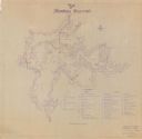
| Date: | 1941 |
|---|---|
| Description: | This is map one of three maps that show trails, roads and fire lanes, utilities, resorts, submerged lakes, vegetation, flowage right lands, and timber righ... |
| Date: | 1941 |
|---|---|
| Description: | This is map two of a set of three and shows boundaries and flowage right lands in red ink. A legend in the lower right corner includes a legend of symbols ... |

| Date: | 1941 |
|---|---|
| Description: | This is map three of a set of three, and shows trails, roads and fire lanes, utilities, resorts, submerged lakes, vegetation, flowage right lands, and timb... |
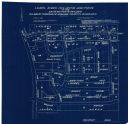
| Date: | 04 1958 |
|---|---|
| Description: | This blueprint map shows additions, sections, and streets. The upper left of the map reads: "Plan for 6ʺ watermain, hydrants & appurtenances." The up... |
If you didn't find the material you searched for, our Library Reference Staff can help.
Call our reference desk at 608-264-6535 or email us at: